
Robin Hood Picking Rods /Mercian Crosses
The following was kindly submitted by contributors to our Discussion Forum:
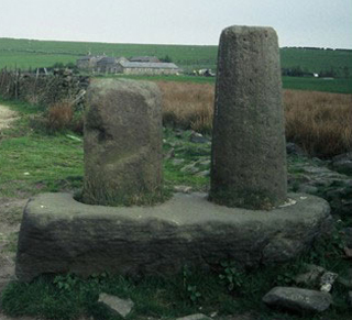
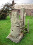
Robin Hood Picking Rods(SK00 6909), sometimes referred to as the Druid or Maiden Stones are ancient stones which stand at the junction of the township boundaries of Ludworth, Mellor and Thornsett, close to the boundary of Chisworth and on the route of an old trackway which shows occasional traces of metalling, indicating its importance as a route from Glossop to Ludworth.
Robin Hood Picking Rods(SK00 6909), sometimes referred to as the Druid or Maiden Stones are ancient stones which stand at the junction of the township boundaries of Ludworth, Mellor and Thornsett, close to the boundary of Chisworth and on the route of an old trackway which shows occasional traces of metalling, indicating its importance as a route from Glossop to Ludworth.
There are many folk tales about their origins but the accepted view seems to be that they are the remains of the base of twin Mercian Pillar Crosses. These crosses are generally to be found in Staffordshire, Cheshire and the High Peak of Derbyshire in an area felt to have been inhabited by a tribal group called the Pecsaetna from whom the Peak District is believed to take its name.
How old are they
The cross was adopted as an emblem of Christianity at the Council of Constantinople in 692, thereafter early missionaries to Anglo Saxon England brought crosses as a symbol of their faith. Simple wooden crosses might have been erected along the wayside to draw crowds to listen to them. Stone crosses appear from the 8th century as Christianity became more established.
 Why were they positioned where they were
They may have been simply way markers for travellers across the wastes with all roads leading to the crosses, they seem to have been used as boundary markers for Abbey Lands and might have been adopted as Parish boundary markers when the Saxons mapped out the parishes in the years leading up to the Norman Conquest.
The practice seems to have ended with the coming of the Normans as they preferred to build Churches. Many Norman Churches, however, have older carved stone remnants incorporated into their fabric suggesting that they and might have been built on the site of a former stone monument.
Why are they in such poor condition
This could be due to a combination of possible factors:
The effects of natural erosion and weathering on the exposed moorlands; destruction and desecration of such images ordered during periods of religious zeal; similar treatment during the English Civil War; Intentional removal and concealment by landowners during the periods of enclosure, where the bases can occasionally be seen re-used in dry stone boundary walls.


We have map records of two crosses which have since dissapeared, from the time when Charles the First decided to enclose and sell off parts of the Commons and commissioned a survey of Mellor Commons in 1640. They eventually draw a median line between three standing landmarks; The Maiden Stones (Robin Hoods Picking Rods), and the now missing Mishaw and Briergreve Crosses, intending to divide the common more or less equally between Thornsett and Mellor.
Do they have any wider significance
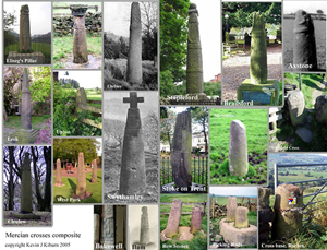
 Kevin Kilburn kindly submitted a map with permission for reproduction and noted that they can also be seen to run from Robin Hood's Picking Rods down the Lyme to Leek and then swing east along the Trent valley to Nottingham, forming a potential boundary along a political divide that may be English Mercia / Viking Mercia or even Welsh Britannica / Anglo-Saxon England. He noted also the association with the crosses of the Lyme and the post-Norman Cistercian abbies on the Welsh marches bordering Cheshire, which seem to have been given land on the western fringe of the Peak District.
In 1407 this exactly similar boundary of the Lyme, connecting the headwaters of the rivers Mersey and the Trent was that proposed by Owyn Glyndwr in the tripartite debenture of 1407 as contested British (Welsh) territory going back to the 9th century.
Are there any further afield
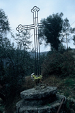
Kevin learned a cross with identical achitecture to those in the Lyme at Beckermet in Cumbria, which reinforced the idea of connection with the Cistercian monastries. This one stands in the churchyard of St Briget, an ancient site adopted in the 12th Century by the nearby Cistercian Calder Abbey. This makes it by far the most remote cross of his stylemand seems to be the exception that proves the rule, could they possibly all have been shafts re-used by the Cistercians when defining their own territories.
Can we tell anything from their design
 There seem to be about 20 of them with a very similar architectural style which suggests either a religious or political power dictating their design. Present day estimates for reproducing them range from £3,000 for a plain 5-foot plain shaft rising to £10,000 for one more ornamented. Kevin makes the observation that the Brailsford cross in particular depicts a warrior that looks very like the 8th Century Mercian king depicted on the Repton Stone, suggesting a possible early date and an indication of a political territorial boundary marker as the reason for their erection.
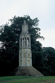
However, the other observation is that they are also clustered near Cistercian abbies or lands owned by the abbeys, especially in the Lyme. After the Conquest, the Lyme was apparently parceled off to several Cistercian houses originating in central and western Cheshire . The tightest cluster of six, all originally within two miles of Wincle Grange is on Cistercian land at Wincle associated with Dieulacresse Abbey at Leek and Combermere near Nantwich.
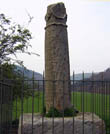 Eliseg is within a mile of Valle Crucis abbey at Llangollen and Beckermet may also fit this latter pattern, being close to Calder Abbey.
Could they have been re-used
It seems possible then that they have served more than one purpose, that they might have started life as 9th Century markers of political and territory and that they were later re-used to Christianise the pagan moorlands and mark the boundaries of religious power, becoming simply waymarkers over time when those territories ceased to exist.
With thanks to Kevin Kilburn, Jonathan Day, Ann Hearle, Warwick Burton and Ron Weston
and with reference to W.G. Collingwood's 'Northumbrian Crosses of the Pre-Norman Age' 1927, reprinted 1989 ISBN 0947992359
and with reference to W.G. Collingwood's 'Northumbrian Crosses of the Pre-Norman Age' 1927, reprinted 1989 ISBN 0947992359
