Highlights of the 2001 Excavations

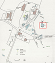
For 2001 to 2002 we received a Local Heritage Initiative Award of �25,000. This enabled us to take on the major task of the excavation of Trench 15, an area 7 metres by 7 metres in the field, which crossed the line of the ditch where Magnetrometry had indicated circular features.
It was anticipated that this might have been an area containing Roundhouses. An extract form Stuart Holden's report, however, illustrates the complexity of the site and the difficulties of interpretation:
It was anticipated that this might have been an area containing Roundhouses. An extract form Stuart Holden's report, however, illustrates the complexity of the site and the difficulties of interpretation:
"An average of 0.29m of topsoil was removed down onto the natural sandstone bedrock without any trace of features cut into them....The ditch could be clearly seen cut into the natural rock running east to west across the trench and it was envisaged that the hut circles would be too, however this was not the case...
Glacial action had produced mixed soils with fragments of sandstone which, when lying within the depressions in the bedrock, created an illusion of features. Despite careful excavatiuon it was not always possible to distinguish genuine features from those occuring naturally"
Glacial action had produced mixed soils with fragments of sandstone which, when lying within the depressions in the bedrock, created an illusion of features. Despite careful excavatiuon it was not always possible to distinguish genuine features from those occuring naturally"

By the end of the excavation 14 meters of the ditch had been exposed, the longest excavated stretch so far. It was found to vary in
width from 1.5 to 2.2m and to average 1.6m deep from the current ground surface. It appeared to have been cut following natural breaks in the Bedrock, giving a linear characteristic along this length.

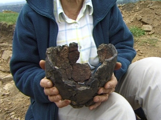
 It was with great excitement that from the bottom of the trench, towards the eastern end, a number of sherds from the same pottery vessel were found. These were later reconstructed and are now known as the Mellor Pot
An extension of T1 was dug in an unsuccessful search for a palisade slot, but instead uncovered a large post-pit. Various explanations were suggested:
...an Iron Age storage pit, part of a Roman signal station...but it was 4 years before we found the real explanation (see 2005) It became apparent that large open areas are the only way to investigate the archaeology fully.
Read the Full 2001 UMAU Archaeological Report
