
Iron Age Roundhouses
What do we know about the dates of the Roundhouses
 The pattern of postholes and intercutting features associated with the Roundhouses is extremely complex and their purpose has proved particularly difficult to unravel. The picture seems gradually to be emerging, however, of at least four separate phases of roundhouse, with gully diameters of between 10m - 12m, with and entrances the North West.
 The pattern of postholes and intercutting features associated with the Roundhouses is extremely complex and their purpose has proved particularly difficult to unravel. The picture seems gradually to be emerging, however, of at least four separate phases of roundhouse, with gully diameters of between 10m - 12m, with and entrances the North West.
In Trench 16 (See 2002 Report) a series of the curvi-linear drainage gulleys which surrounded the Roundhouses, appear to be the earliest phase of the features,
with Radio Carbon dating them from 380BC to 520BC.
with Radio Carbon dating them from 380BC to 520BC.

Trench 26 (See 2004 Report) exposed a large area with a total of 19 intercutting linear features. These were interpreted as continuous settlement over a long period, outside the perimeter of the inner ditch.
What do we know about their construction
Trench 20 in 2002, revealed a large circular feature with stones arranged around its sides and one laid flat in the centre of its base, which could possibly represent the position of a large timber upright with smaller posts arranged around it on pads of stone. It is also possible, however, that that the walls of some structures might have been entirely constructed of stone but reused during a later period,which would have left no trace in the archaeological record. See The Roundhouse Project for alternative styles and construction of Roundhouses.
How big was a roundhouse

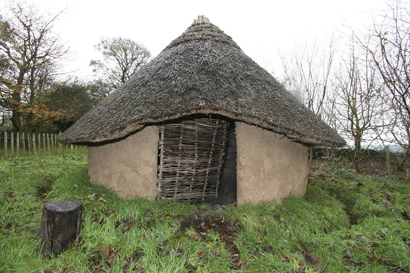
The Reconstructed Roundhouse

Differences in character between drainage ditches, stone lined gulleys and post hole trenches (See 2002 Report) suggest that change was a continuous process, with apparently deliberate infilling indicating organised effort. At some times the roundhouse or crucible fragments indicate domestic or industrial use, at others the area seems to be partly enclosed and divided, possibly for stock control.
How big was a roundhouse

In 2003 the planned programme of excavation meant that we were able to trace an almost perfect horseshoe shape of one individual roudhouse, which measured an amazing 11 metres in diameter. Trench 21 to the north of Trenches 3 and 16 traced a J shape round a clump of trees back to the Rhodedendron bed. It was difficult to make out where the orange brown boulder clay was replaced by Natural Sandstone Bedrock but just possible to follow a line where the plated bedrock had been levered out to form a shallow channel, until the boulder clay, with higher charcoal content appeared again. The excavation revealed an almost perfect horseshoe shape around 13 meters in diameter.
How big was the settlement
 Trenches 28 and 29 (See 2004 Report) confirmed the presence of a further significant number of archaeological features, indicating that the settlement located within Trench 26 is not the furthest extent of occupational archaeology from the inner enclosure ditch, both of these trenches were exposed but not excavated.
 Trenches 28 and 29 (See 2004 Report) confirmed the presence of a further significant number of archaeological features, indicating that the settlement located within Trench 26 is not the furthest extent of occupational archaeology from the inner enclosure ditch, both of these trenches were exposed but not excavated.
The Reconstructed Roundhouse
In 2002, students from the Ridge Danyers Sixth Form College were involved in a European Community Culture Programme, The Mnesonyme Project, to reconstruct an Iron Age Roundhouse on the site, which remains in place, providing an evocative reminder of how the area might have looked during this period.
Read an overview of Mellor within the Region in the 2001 Report.
Read more about the Iron Age Period in Britain
Copyright: All items may be reproduced with permission from the
Mellor Archaeological Trust
