The Prehistoric Ditches
Identifying the dates of the Ditches

Putting dates to the finds and features of the Old Vicarage site from the Bronze Age through the Romano British times is not a simple task. In the early days we thought that we had an Iron Age Hilltop enclosure with both an inner and outer ditch system. Further discoveries indicated however that it was as early as the Late Bronze Age that this central spur was enclosed by the narrow and shallow outer ditch system which we have excavated in sections in fields to the north and south. Unfortunately we have not been granted access to the land at the top of the hill and to the east, but the line of the present stone walls suggests that the enclosure may have run round the top of the hill enclosing about 20 hectares
. What purpose could the small outer ditch have served
The size and nature of the outer ditch suggest that it could only have offered a very limited defensive function. It might have offered some small protection to livestock and crops from predators and could have corralled grazing livestock but was possibly more likely to have been a boundary delineation or marker. Furthermore the warmer climate of the Bronze Age would also have made this area well suited to growing crops.
Were the two ditches made at the same time
 Our early ideas that the two ditch systems had been used together to create one large landscape has not been confirmed by subsequent investigation. Geophysics and excavation on these ditch systems have given us valuable information about the extent, nature and age of the prehistoric settlement, but the two points where the ditches might be expected to meet or overlap are still inaccessible. One potential area being under the Church Graveyard and the other either under the paved area by the Old Vicarage garage or under the garage itself.
 Our early ideas that the two ditch systems had been used together to create one large landscape has not been confirmed by subsequent investigation. Geophysics and excavation on these ditch systems have given us valuable information about the extent, nature and age of the prehistoric settlement, but the two points where the ditches might be expected to meet or overlap are still inaccessible. One potential area being under the Church Graveyard and the other either under the paved area by the Old Vicarage garage or under the garage itself.
 How do we know how old the ditches are
 Dating evidence tells us that parts of the ditch system were certainly in use during the Iron Age period but some sections had apparently much earlier origins. These are difficult to define as there was such a gradual transistion from the Bronze Age into the Iron Age rather than a definitive event and any hill settlement such as Mellor is likely to have undergone several phases of development, as does Almondbury (20 miles to the North East of Mellor). Carbon dating results from the content of the top fill of a section of outer ditch give us a date of around 400BC for the end of its use.
 Dating evidence tells us that parts of the ditch system were certainly in use during the Iron Age period but some sections had apparently much earlier origins. These are difficult to define as there was such a gradual transistion from the Bronze Age into the Iron Age rather than a definitive event and any hill settlement such as Mellor is likely to have undergone several phases of development, as does Almondbury (20 miles to the North East of Mellor). Carbon dating results from the content of the top fill of a section of outer ditch give us a date of around 400BC for the end of its use.
 What do we know about the Deep Inner Ditch
 At around 500 BC, possibly due to the change of climate, the high hillforts in other parts of Derbyshire seem to have been abandoned, and it is possible that one of these chieftains may have decided to relocate himself to the old area of Mellor. Our main evidence for the change of use at this time is the creation of the deeper inner ditch.
 At around 500 BC, possibly due to the change of climate, the high hillforts in other parts of Derbyshire seem to have been abandoned, and it is possible that one of these chieftains may have decided to relocate himself to the old area of Mellor. Our main evidence for the change of use at this time is the creation of the deeper inner ditch.
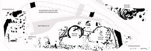
  It is typically three meters wide and three meters deep, cut into the rock or the band of boulder clay crossing the site. It has been tracked from near the entrance to the Old Vicarage in the east, to pass under the house and on through Trench 1 to the south-west corner of the garden, enclosing around 0.7 hectares.
 There was one entrance on the east and one on the north-west with an avenue, now revealed in the lines of small upright stones, running between the two. In some places what may be a palisade slot runs inside and parallel to the edge, often characterised by two lines of vertical angular stones. The excavation of Trench 25 in 2003 also demonstrated that the ditch would have run right along the contour line of the break of the slope, making it a prominent and visible statement of ownership to anyone approaching from below.
 These facts, together with the crude Iron Age pottery in the lower levels and Roman artefacts in the higher, suggest that this fortified settlement was the site of Iron Age leaders who later developed a more Romanised life-style. The depth of the ditch, the presence of a palisade and the size of the area it enclosed suggest that its function was at least partly defensive. We can also conclude from the presence of a type of pottery called briquetage , used for transporting salt, that it may also have been a centre for trading.
How were the ditches constructed
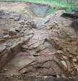
Many sections of the ditch were cut into the formidable looking plated bedrock. The Geological Report written by Fred Broadhurst suggests that much of the ditch could actually have been excavated with a tool similar to a mattock, with the digger standing facing to the east, from which position it becomes much easier to lever off plates of bedrock. This is particularly noticable where some sections of the unearthed ditch have run particularly straight, following the course of least resistance between two joints in the bedrock.
How did people live within the Iron Age Hilltop Settlement

We know that the prehistoric residents of the hilltop lived in Roundhouses, as we find the curvilinear drainage gullies which were cut to take the run off of rainwater from the thatched roofs. Roundhouse gullies, with areas of pits and post-holes which seem to be the 'backyards' of the dwellings, are found inside the defensive ditch in T16, 21, & 23 and just outside in T26 & 36 close by to where the magnificent Bronze Age Flint Dagger was found in 2004.
See 2001 Archaeological Report Conclusions
