
The Bronze Age Period at Mellor
Around 4,000 to 2,500 years ago
Around 4,000 to 2,500 years ago
 What attracted Bronze Age people to the Region
Mellor lies in a cusp of land bounded on the south-west by the River Goyt heading up into the heart of the Peak District, on the north-west by the River Etherow leading up the Woodhead valley towards Yorkshire, and on the east by a long ridge, which looks across the Ladygate Brook towards Kinder Scout.
Climate changes during the Bronze Age in Northern Britain encouraged people to leave the more waterlogged lowlands where find spots had previously been concentrated, around river esturies, and migrate to the middle and upper reaches of the river systems, such as the uplands at Mellor. The top of Mellor Moor is at 327 m (1072 feet); the lowest point, where the rivers join, is at 72 m (235 feet). It is this topography between peak and plain which determined the settlement in Mellor.
Climate changes during the Bronze Age in Northern Britain encouraged people to leave the more waterlogged lowlands where find spots had previously been concentrated, around river esturies, and migrate to the middle and upper reaches of the river systems, such as the uplands at Mellor. The top of Mellor Moor is at 327 m (1072 feet); the lowest point, where the rivers join, is at 72 m (235 feet). It is this topography between peak and plain which determined the settlement in Mellor.
Three spurs lead west from the ridge. The central spur rises from the ridge and then drops in a series of knolls, on the first of which stands Mellor Church alongside the Old Vicarage. To the north, Ludworth Moor contains Brownlow Bronze Age Barrow. To the south, Mellor Moor has Shaw Cairn Bronze Age Barrow at its highest point.
How did the Geology of the area affect the settlement

The Mellor Hilltop site held many advantages. The spine of upland running east to west across the hamlet between Mill Brow Valley and Mellor Brook Valley is one of the few areas where the solid rocks are not hidden by the cover of boulder clay. At centre of this spine is a roughly oval hill mass with gently curving summit and a readily available source of water from several springs issuing from base of sandstone. Despite the elevation of 700-900 feet, the hilltop offered good agricultural land, of light free draining soils on the sandstone outcrop, together with some reasonably flat land and gentle slopes. Furthermore, the steep scarp around the junction of the Woodhead Hill Rock with the Lower Coal Measures provided a defensive feature.
Identifying the Bronze Age Features

Putting dates to the finds and features of the Old Vicarage site from the Bronze Age through the Romano British times is not a simple task. In the early days we thought that we had an Iron Age Hilltop enclosure with both an inner and outer ditch system. Further discoveries indicated however that it was as early as the Late Bronze Age that this central spur was enclosed by the narrow and shallow outer ditch system which we have excavated in sections in fields to the north and south. Unfortunately we have not been granted access to the land at the top of the hill and to the east, but the line of the present stone walls suggests that the enclosure may have run round the top of the hill enclosing about 20 hectares
.What purpose could the small outer ditch have served
The size and nature of the outer ditch suggest that it could only have offered a very limited defensive function. It might have offered some small protection to livestock and crops from predators and could have corralled grazing livestock but was possibly more likely to have been a boundary delineation or marker. Furthermore the warmer climate of the Bronze Age would also have made this area well suited to growing crops.
Are there any more indications of Bronze Age Settlement

 Two of the large roundhouse gullies found on the site just outside the deep inner ditch, also appear to date from the late Bronze Age rather than the Iron Age.
A Radiocarbon Date recovered from a small pit in Trench 27 in 2004 gave a date of 1750-900 cal BC (Beta 202316, 2 sigmas), much earlier than the roundhouses within the inner ditch.
In the same area it seems that the complex pattern of Iron Age gullies may effectively mask earlier features. Excavation in 2004 exposed a further complex series of intercutting pits and large numbers of Fire Cracked Pebbles.
Instead of the expected Iron Age dates however, environmental analysis of the traces of hazelnut, burnt bone and cereal type pollen gave very early radiocarbon dates of BC 2920 to 2650 from the Late Neolithic and Early Bronze Age.
Instead of the expected Iron Age dates however, environmental analysis of the traces of hazelnut, burnt bone and cereal type pollen gave very early radiocarbon dates of BC 2920 to 2650 from the Late Neolithic and Early Bronze Age.
Do we have any other Bronze Age Finds
 In 2004 a magnificent early Bronze Age Flint Dagger was found in an extension to Trench 26 on the Old Vicarage site. However, it did not appear to be associated with any natural feature and was probably more likely to have been deposited here for ritual or sacred reasons. It is a rare and high status artefact, so the trench extension was protected and backfilled for further investigation in 2005 but unfortunately no associated finds or features were discovered in the immediate area.
Around the rest of the site there are a vast number of post-holes and stake holes all lying in the rock or clay just below a small depth of topsoil, which may potentailly have a Bronze Age date, but these have proved impossible so far to date and interpret .
Other sites nearby
 It was known however, that interesting funerary archaeology had been recorded in antiquity on the spurs at Brownlow and Shaw Cairn to the north and south. In 2008 therefore, the Burial Cist at Shaw Cairn was re-investigated and fortunately we found that parts had not been too badly damaged by earlier excavations. A Bronze Age Burial Cist was reopened within the Cairn and incredibly around eighty Amber Beads found from a necklace were found, each individually shaped and pierced.
 It was known however, that interesting funerary archaeology had been recorded in antiquity on the spurs at Brownlow and Shaw Cairn to the north and south. In 2008 therefore, the Burial Cist at Shaw Cairn was re-investigated and fortunately we found that parts had not been too badly damaged by earlier excavations. A Bronze Age Burial Cist was reopened within the Cairn and incredibly around eighty Amber Beads found from a necklace were found, each individually shaped and pierced.
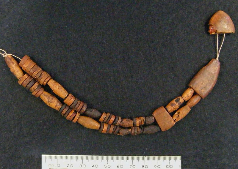
In the opinion of Dr Alison Sheridan of the National Museums of Scotland:
The necklace belonged to a woman of very high status, valued greatly by her society to be buried with something so beautiful and rare, which is proving to be one of most important Bronze Age discoveries in the North West in recent years.
The the associated finds of cremated bone, sherds of pottery and traces inside the food vessel will now be researched to see if they can give us further valuable information about this site.
Read more about the Bronze Age in Britain on the Channel 4 Time Team website
Copyright: All items may be reproduced with permission from the
Mellor Archaeological Trust
